Vöktun virkra jarðskjálftasprungna og kortlagning jarðskjálftaáhættu í þéttbýli - verkefni lokið
Fréttatilkynning verkefnisstjóra
Verkefnið hefur aukið til muna skilning okkar á eðli íslenskra jarðskjálftahreyfinga, sérstaklega þeim í nærsviði stórra jarðskjálftasprungna, og breytileika þeirra. Þannig hefur verið lagður grundvöllur að endurmati á jarðskjálftahættu á Íslandi sem er undirstaða jarðskjálftahönnunar mannvirkja.
Yfirlit verkefnis
Húsavíkur-Flateyjarmisgengið á brotabelti Norðurlands er eitt það stærsta á Íslandi. Sterkir jarðskjálftar sem valda skemmdum hafa endurtekið átt sér stað á því, sá síðasti árið 1872 en rannsóknir benda til að misgengið geti leyst úr læðingi jarðskjálfti af stærðinni 6.8. Stærsta jarðskjálftahrina á Norðurlandi síðustu áratuga varð veturinn 2012-2013. Jarðskjálftarnir mældust á ICEARRAY II, nýja fylkingu hröðunarmæla og GPS-mæla á Húsavík, sem er einmitt staðsett ofan á misgenginu. Mælafylkingin fylgist í rauntíma með hægfara aflögun jarðskorpunnar í kringum misgengið, hröðum yfirborðshreyfingum í jarðskjálftum sem verða við brot jarðskorpunnar, og jarðskjálftahreyfingum sjúkrahússins á Húsavík. Mælingarnar í jarðskjálftunum hafa nú verið rannsakaðar, ásamt þeim sem mældust á ICEARRAY I-hröðunarmælanetið í Hveragerði í jarðskjálftanum í Ölfusi 29. maí 2008 og eftirskjálftum hans, en einnig mælingar á öllum jarðskjálftum á Íslandi stærri en 5 að stærð. Mælingarnar eiga það sammerkt að sýna umtalsverðan breytileika í jarðskjálftahreyfingum. Í verkefninu voru því eðlisfræðileg og eigindleg líkön gerð fyrir bæði upptök jarðskjálfta á Íslandi og yfirborðshreyfingar af þeirra völdum og hafa líkönin verið kvörðuð með aðferðum Bayesískrar tölfræði. Fyrir lítil svæði eins og Húsavík þar sem jarðfræði og landslag innan bæjarins er fjölbreytt sýna niðurstöðurnar að staðbundnar aðstæður valda um 57% af breytileikanum í yfirborðshreyfingunum. Í Hveragerði hins vegar sem liggur á flötu hraunlagi valda staðbundnar aðstæður um 13% á meðan jarðskjálftarnir sjálfir valda 61% af breytileikanum. Þó ber að geta þess að í Hveragerði liggja hraunlög ofaná mýkri jarðlögum og þar eru yfirborðshreyfingarnar talsvert frábrugðnar þeim sem mælast á eldra bergi. Á stærri svæðum eins og á Suðurlandi þá eru yfirborðshreyfingarnar umtalsvert stærri í nærsviði jarðskjálftasprungna á Íslandi en í öðrum löndum. Á móti eru hreyfingarnar umtalsvert minni langt frá upptökunum. Eðlisfræðileg og eigindleg líkön hafa verið gerð sem lýsa þessum eiginleikum á nákvæmari hátt en áður hefur verið gert og þau notuð til þess að meta breytileika á mati á jarðskjálftahættu á Norðurlandi. Niðurstöðurnar sýna að fyrri hættumöt hafa notað líkön sem eiga ekki við íslenskar jarðskjálftahreyfingar og auk þess fela í sér mikla óvissu á jarðskjálftahættu. Á móti er hættumat sem er byggt á líkönum sem gerð hafa verið í verkefninu mun raunhæfara og felur í sér minni óvissu, og leiðir af sér áreiðanlegra hættumat. Í verkefninu hefur því í fyrsta skipti verið gert heildstætt mat á áhrifum jarðskjálftaupptaka og staðbundinna áhrifa á yfirborðshreyfingar í jarðskjálftum. Auk þess hafa allar óvissur verið metnar með aðferðum Bayesískrar-tölfræði, sem er í fyrsta skipti á sviði jarðskjálftaverkfræði á Íslandi. Verkefnið hefur því aukið til muna skilning okkar á eðli íslenskra jarðskjálftahreyfinga, sérstaklega þeim í nærsviði stórra jarðskjálftasprungna, og breytileika þeirra. Þannig hefur verið lagður grundvöllur að endurmati á jarðskjálftahættu á Íslandi sem er undirstaða jarðskjálftahönnunar mannvirkja.
Yfirlit afurða verkefnisins
- 3 doktorsritgerðir
- 2 meistararitgerðir
- 13 ritrýndar vísindagreinar í alþjóðlegum viðurkenndum
tímaritum
- 17 ritrýndar vísindagreinar á stærstu alþjóðlegu heims- og
Evrópuráðstefnum í jarðskjálftafræði og jarðskjálftaverkfræði
- 4 ritrýndar vísindagreindar á alþjóðlegum ráðstefnum í
jarðskjálftafræði og jarðskjálftaverkfræði
- 20 fyrirlestrar á sex alþjóðlegum ráðstefnum
- Mælakerfi í sjúkrahúsinu á Húsavík
- Ný landfræðileg kort af jarðfræði, jarðmótunarferlum,
landslagi og eiginleikum byggðar Húsavíkur og nágrennis

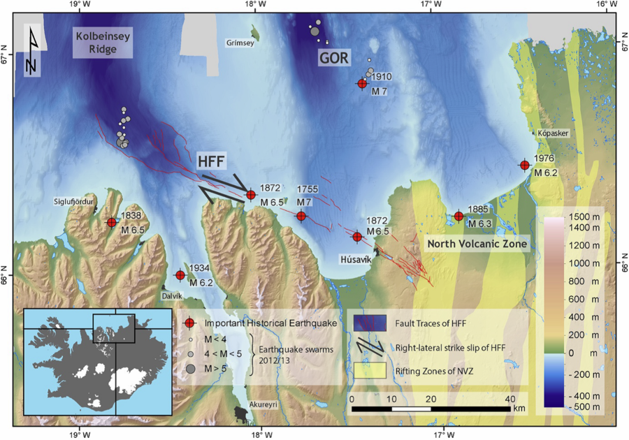
Figure 3. Tectonic situation of the town of Húsavík, situated on the Húsavík-Flatey Fault (HFF) in the seismically active Tjörnes Fracture Zone (TFZ) of North Iceland. On land, the Northern Volcanic Zone (NVZ) is a part of the extensional tectonic margin that is the Mid-Atlantic Ridge as it goes through East Iceland, and the TFZ takes up its westward ridge-jump over to the Kolbeinsey Ridge north of Siglufjordur. The HFF is the main transform fault of the TFZ system on which an overall right-lateral strike slip movement takes place, leaving clear marks in the bathymetry (S. Magnúsdóttir, Brandsdóttir, Driscoll, & Detrick, 2015). The other main tectonic structure is the Grímsey Oblique Rift (GOR) which is twice as active than the HFF (parallel to HFF approximately from Kópasker to the channel east of Grímsey island, where it continues northwest to the Kolbeinsey Ridge), but is a heavily segmented fault on which active volcanism is present (Metzger & Jónsson, 2014). A third structure, the elusive Dalvík Lineament (DL) may be present and parallel to the HFF, but is much less active (Stefánsson, Guðmundsson, & Halldórsson, 2008). The yellow shaded areas in the NVZ represent the extent of the fizzure swarms of separate volcanic systems on the extensional margin, and the solid thin lines represent the main faults and fissure swarms of the transform zone (Hjartardóttir, Einarsson, Magnúsdóttir, Björnsdóttir, & Brandsdóttir, 2016). Red crossed dots mark important historical earthquakes (with year and magnitude; (Stefánsson et al., 2008), and gray-shaded dots indicate the locations of the most significant earthquakes during the 2012-2013 earthquake sequence on the western ends of the HFF and GOR, respectively. (Waltl, Halldorsson, Pétursson, & Fiebig, 2018)
Summary of the project
The Husavik-Flatey Fault in the Tjörnes Fracture Zone (TFZ) in North Iceland is one of the largest transform faults in the country. It has repeatedly caused strong damaging earthquakes, the last one in 1872. In the winter of 2012-2013 an intense earthquake sequence, the largest one in over 30 years, took place in the TFZ. The seismic ground motions were recorded on the new ICEARRAY II, a strongmotion, structural and geodetic array in and around Húsavík, which is located on the fault. This array is designed to monitor in real-time both the slow tectonic movements of crustal deformation, fast movements of earthquake crustal rupture, and the vibrations of the Húsavík hospital building during earthquakes. The recordings of ICEARRAY II in Húsavík have now been analysed, along with recordings from the only other strong-motion array in Iceland, the ICEARRAY I in Hveragerði, that recorded the Ölfus earthquake on 29 May 2008 and its aftershocks. Moreover, data from Icelandic earthquakes largere than magnitude 5 have been analysed. The measurements all show considerable variations of seismic motions. Therefore, both the source process of Icelandic earthquake and the seismic ground motion characteristics have been modeled using physical and empirical models and calibrated using advanced Bayesian statistical methods. The results show that on a local scale, the earthquake motions may vary considerably over small distances (tens to hundreds of meters). In Húsavík local geology and landscape changes considerably with location and is responsible for up to 57% of the ground motion variability. On the contrary, Hveragerði is located on a relatively flat lava-rock layer and thus the variability is largely due to differences in the earthquakes themselves (61%) while the differences between locations inside the town are responsible for at least 13%. In Hveragerði however the hard lava-layers lie on top of softer sediments where the ground motion characteristics are considerably different than on older bedrock. On a regional scale when compared to other seismic countries, ground motions from Icelandic earthquakes are considerably larger near the seismic fault and smaller at far distances from the fault. This is an important characteristic that we have accurately captured by developing multiple new models and used them to estimate the sensitivity of the seismic hazard for North Iceland. We show that previous hazard estimates have not accurately evaluated the hazard and moreover, are associated with considerable uncertainty. Effectively therefore, using the new models developed in this study is likely to considerably improve the hazard, reduce the uncertainty, and overall enhance our confidence in the reliability of the hazard. In this project the first comprehensive evaluation of the earthquake source, path and site effects has been carried out for seismological and engineering applications. Moreover, it has for the first time in engineering seismology in Iceland quantified all associated uncertainties using advanced Bayesian statistical methods. This project has therefore laid the groundwork on which a comprehensive reassessment of seismic hazard in Iceland can be carried out, which is the basis of earthquake resistant design of buildings in seismic regions.
Summary of project impacts
- 3 Doctoral dissertations.
- 2 Masters theses.
- 13 peer-reviewed scientific papers in ISI accredited
international journals.
- 17 peer-reviewed conference papers at major conferences on
earthquake engineering and engineering seismology.
- 4 peer-reviewed conference papers at international
conferences on earthquake engineering and engineering seismology, and
geotechnical engineering.
- 20 presentations at 6 international conferences and meetings
- Permanent structural monitoring system in the Húsavík
hospital building
- New maps of the geology, geomorphology, landscape and
building stock of Húsavík, North Iceland
Heiti verkefnis: Vöktun
virkra jarðskjálftasprungna og kortlagning jarðskjálftaáhættu í þéttbýli / Real-time
earthquake fault monitoring and seismic risk assessment using dense geodetic
and seismic arrays in urban areas
Verkefnisstjórar: Benedikt Halldórsson, Háskóla Íslands og Sigurjón Jónsson, King
Abdullah University of Science and Technology (KAUST)
Tegund styrks: Öndvegisstyrkur
Styrkár: 2014-2016
Fjárhæð styrks: 76,428 millj. kr. alls
Tilvísunarnúmer Rannís: 141261